What is Local Planning Scheme No. 3 (LPS 3) and why replace it?
LPS 3 is the Town’s current statutory planning document guiding land use, zoning, development scale, and housing density. It provides the framework for local growth and decision-making. However, under WA’s planning regulations, local governments must review their schemes every five years. As a result, a new scheme, LPS 4, is being prepared to replace LPS 3.
Prior to preparing a local planning scheme, the Town is required to prepare a local planning strategy which primarily must set out the long-term planning directions for the Town and apply any State or regional planning policy that is relevant to the Strategy. This was completed in 2022. The Local Planning Scheme sits under the Strategy and is the legal document which implements the Strategy’s vision.
LPS 4 will retain many of LPS 3’s core controls but also reflect updated state and local planning policies, as well as evolving community needs. The process follows legal requirements under the Planning and Development Act, 2005 and Planning and Development (LPS) Regulations, 2015 and occurs in two key stages:
Stage 1 involves Council agreeing to start the process, undertaking necessary studies, and early community engagement. A draft Scheme Text and Map are then prepared.
Stage 2 includes a formal Council resolution to advertise the draft LPS 4 followed by WA Planning Commission (WAPC) consent to advertise. A 90-day public consultation period then follows. Feedback is reviewed, changes may be made, and the final draft is sent to the WAPC and the Minister for Planning for final approval.
The whole process can take several years, depending on the extent of changes and any additional requirements from the WAPC or the Minister.
Final approval rests with the Planning Minister after recommendations from Council and the WA Planning Commission. The LPS 4 estimated project timeline is explained on the next panel.
View the LPS 3 Scheme Map
LPS 4 project timeline
2018
Council endorses Report of Review
Report of Review prepared as required under the Planning and Development (LPS) Regulations which require a five year interim review of all WA Schemes.
Refer Report of Review to WAPC
WAPC endorses Report of Review which recommends that a new Scheme be prepared.
2019
Council endorses Local Planning Strategy: The key strategic planning document that details the long-term vision for growth and a blueprint for the development of neighbourhoods and commercial centres.
Public consultation: Council adopts Strategy for purposes of public consultation.
2021
WAPC approves advertising of Strategy.
2022
Strategy adoption: Council adopts Strategy.
WAPC endorses Strategy: Published and operational.
2025
Resolution to prepare LPS 4: Council officially begins process of preparing a new Planning Scheme.
Early community consultation begins: Drop-In Session for (non-statutory) consultation seeking input on proposals for Planning Areas F, G, H and I.
Mid to late 2026 (we are currently at this stage)
Draft LPS 4 considered by Council: Seeking Council approval to formally advertise the draft of LPS 4.
Late 2026/Early 2027
Request to advertise (may take further modifications if changes requested by WAPC).
To be confirmed - 2027
Minister approves LPS 4 for advertising:
Minister either approves Scheme for advertising or requires modifications.
Formal consultation (advertising): Scheme is advertised for 90 days and submissions received.
To be confirmed 2027/28
Modified LPS 4 goes back to WAPC:
Submissions considered. Scheme is modified and schedule of submissions is presented to WAPC for endorsement.
To be confirmed 2028
Minister decision: Minister approves LPS 4. Scheme is gazetted. Process complete.
State Strategic Planning Framework
The State Planning Strategy sets the overarching framework for coordinated land use planning and development across WA.
Its vision is to support sustained growth and prosperity through diversity, liveability, connectedness, and collaboration. It provides the principles and strategic direction that guide planning at the state, regional, and local levels.
At the regional level, the Western Australian Planning Commission (WAPC) prepares various planning instruments such as regional strategies and planning schemes. These include documents highly relevant to the Town, such as:
The Metropolitan Region Scheme (MRS): This broad zoning framework identifies areas for regional open space, infrastructure, land uses and environmental protection. Local planning schemes must align with the MRS to ensure consistent land use across local governments.
Perth and Peel @ 3.5 Million Strategy (2018): This framework sets housing targets across metropolitan Perth to accommodate a projected population of 3.5 million by 2050. It encourages 47% of new housing to be delivered within established urban areas, promoting infill development over urban sprawl. Infill is the development of existing urban areas at a higher density than currently exists.
Given the Town’s very limited undeveloped land supply and strong community values around heritage, green space, and local character, new housing will need to be delivered through moderate and well-planned density increases in select locations. These include activity centres and key transport (urban) corridors rather than widespread rezoning.
The Central Sub-regional Planning Framework: This applies to the Town and 18 other local governments in the central metropolitan area. It supports infill development primarily within urban corridors, activity centres, and train station precincts. Public transport availability is a key factor in determining suitable areas for increased dwelling density. The Town is expected to contribute 890 new dwellings towards the region’s total dwelling target of 215,000 by 2050.
To meet housing targets while preserving valued heritage areas, the new LPS 4 will propose targeted growth. This includes:
Activity Centres (e.g. the Town Centre and Petra Street): These offer opportunities for sustainable, mixed-use development that supports local jobs, transport access, and community vibrancy. Petra Street will be further guided by a separate structure plan at a later date.
Transport Corridors (e.g., Canning Highway and Marmion Street): These corridors are aligned with high-quality public transport and cycling infrastructure, making them prime locations for increased density and more diverse land uses.
In summary, the Town’s planning approach, guided by State and sub-regional strategies, focuses on accommodating future growth through well-managed infill development while protecting its unique heritage and character. This is reflected in the Town’s Local Planning Strategy, explained on the next panel.
Local Planning Strategy
What is the Local Planning Strategy (LPS)?
In 2022, the Council and the WAPC endorsed the Town’s LPS, establishing a long-term vision to guide growth and development over the next 10 to 15 years. The Strategy serves as the foundational document
for shaping neighbourhoods and commercial centres and will inform the development of LPS 4, particularly in land use zoning and development controls. It consists of two parts:
Part 1 includes the strategic vision, planning map, and actions.
Part 2 provides background research and analysis.
Key elements include:
- Preserving existing low-density residential areas.
- Exploring targeted areas for increased housing density.
- Investigating the potential redevelopment of key strategic sites.
- Reinforcing the Town Centre as the core commercial hub.
- Highlighting the Petra Street Mixed Use area’s unique local role and future as a district centre.
- Promoting efficient, sustainable community and recreational facility planning.
- Ensuring strong connectivity between land uses and infrastructure within and beyond the Town.
Strategy recommendations
As a starting point the Town is reviewing the housing component of the Strategy and the recommendations for how the Town’s planning framework can best meet the Town’s future housing needs
and State Government dwelling targets, including where different housing types and densities should be located in the Town.
To meet the State’s dwelling targets by 2050, the Strategy focuses on intensifying development in key areas abutting Canning Highway and close to the Town Centre and infill development in areas along Petra and Marmion Street. This proposed intensification is subject to further consideration of heritage, traffic, regional road needs, parking, built form and noise impacts.
The above locations have been identified as ‘Planning Areas’ as outlined on the Strategy Map. These areas are targeted for further study and investigation as part of the preparation of LPS 4 and some areas may see dwelling density R-Code change as a result, subject to Council endorsement.
The Town would like to hear your feedback and aspirations on the type and location of additional housing in the four Planning Areas F, G, H and I.
View the Local Planning Strategy Map
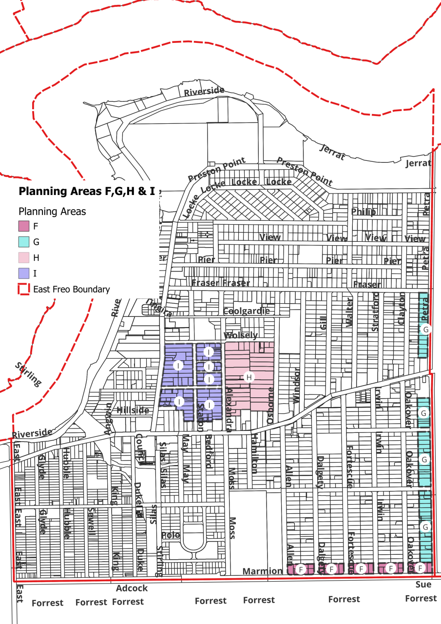
Planning Areas F, G, H & I
Local Planning Strategy - Planning Directions
The Planning Areas F, G, H and I are identified as Urban Corridors. Urban Corridors are locations that provide connectivity between train station precincts and Activity Centres and are served
well by public transport. Activity Centres are places that include a mix of activities such as commercial, retail, entertainment, housing, and includes shopping centres.
The Strategy identifies these areas as having the potential to deliver urban consolidation, increased housing diversity, and additional development which can align with heritage protection and the local character.
The LPS 4 focus for these areas is to consider a higher density of development and promote a variety of housing types by:
- permitting redevelopment at the same density as currently exists on some lots.
- allowing development of housing types suited to an ageing population in line with State planning policy.
- respecting and enhancing the established residential character.
- seeking community input to help draft local policies which supplement the R-Codes of WA and which reflect local character.
An urban design consultant has assisted in developing R-Code proposals (dwelling densities) for Planning Areas F, G, H and I. Site plans and perspectives which demonstrate the development of different housing types on
lots of varying sizes at the proposed dwelling density are demonstrated on other panels.
These proposals have been informed by the recommendations of the Strategy for infill development.
The Town is focused on gathering feedback regarding the proposed dwelling densities (R-Code) for the Planning Areas F,G,H and I.
The intent being to engage early with the community, as the feedback will be important in the LPS 4 drafting process and reporting to Council.
Planning Areas F, G, H and I Map
R-Codes explained
The Residential Design Codes of WA (R-Codes) is a State Planning Policy and it is the cornerstone of residential planning and development in WA.
The R-Codes regulate the design of housing developments. These codes specify development standards including lot size, setbacks, building heights, and open space requirements, so it is a framework for designing and assessing residential developments.
The R-Codes are read into every local planning scheme by reference and apply to single houses, grouped dwellings, and multiple dwellings across various density codings in all urban and rural settings.
Lot Sizes for Additional Dwellings (single, grouped and multiple dwellings).
The required lot size depends on the zone and density code which has been assigned to the property. The R-Code sets out the minimum and average lot sizes for single houses, grouped dwellings and multiple dwellings as in the examples in the table below. In order to subdivide and develop additional houses meeting both the minimum and average lot size, as well as the minimum frontage is required.
Residential Density Code
|
Min. Lot Size (m²)
|
Avg. Lot Size (m²)
|
Rear Battleaxe Lot (m²)
|
Min. Frontage (m)
|
| R12.5 |
700 |
800 |
762.5 |
17 |
| R17.5 |
500 |
666 |
587.5 |
12 |
| R20 |
350 |
450 |
450 |
10 |
| R25 |
300 |
350 |
425 |
8 |
| R30 |
260 |
300 |
- |
- |
| R40 |
180 |
220 |
- |
- |
| R30 multiple dwelling |
- |
300 |
- |
- |
Under the R-Codes, up to R25 is considered low density, R30 to R60 is considered medium density and R80 and above is considered high density.
LPS 4 will assign an R-Code to residential properties and is one of the main ways in which dwelling density is allocated.
Notes:
1. Single house – one house on a freehold (green) title.
2. Grouped dwellings – town houses, terrace or row houses and villas (duplex, triplex etc.) on strata titles.
3. Multiple dwellings – apartments or flats on strata titles.
4. The R-Code number indicates the permitted number of dwellings per hectare.
5. The higher the R-Code number, the smaller the area of land required to accommodate each dwelling.
Planning Areas F, G, H and I
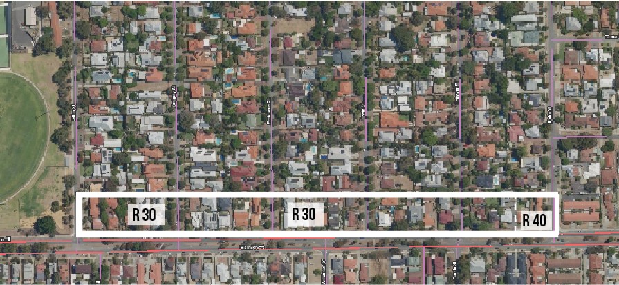
Planning Area F
Marmion Street - Between Allen and Petra Street
Local Planning Strategy Action - Urban Corridor
Investigate the potential to continue with the higher density pattern of housing development that already exists, or potentially increase this dwelling density (R-Code), for some properties in this Planning Area.
Planning Area F - existing R-Code
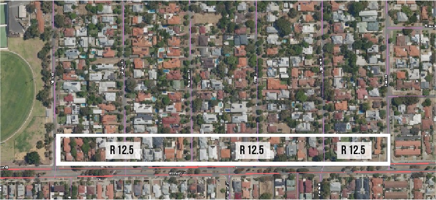
Planning Area F - proposed R-Code
Planning Area G
Petra Street - Canning Highway to Fraser Street and Canning Highway to Marmion Street (residential lots only)
Local Planning Strategy Action - Urban Corridor
Investigate the potential to continue with the higher density pattern of housing development that already exists, or potentially increase this dwelling density (R-Code), for some properties in this Planning Area.
Planning Area G - existing R-Code
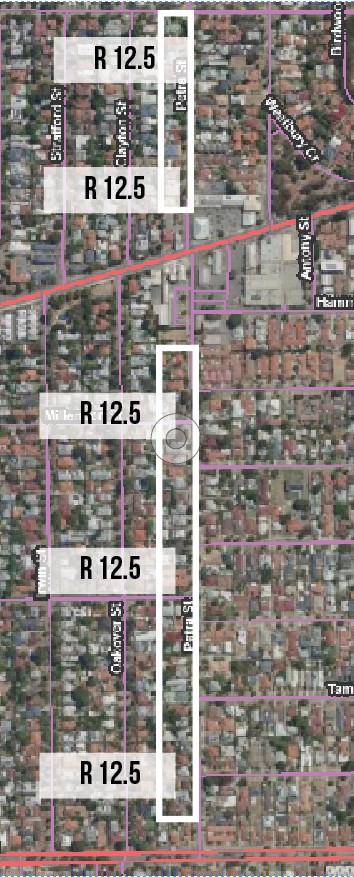
Planning Area G - proposed R-Code
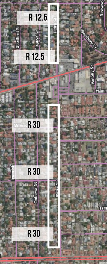 Note: No change proposed between Fraser and Canning Highway.
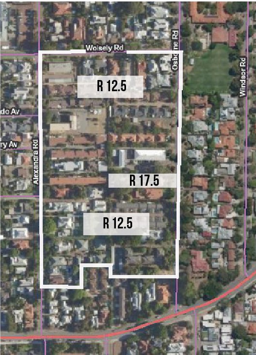
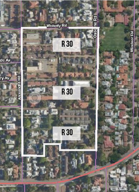
Planning Area H
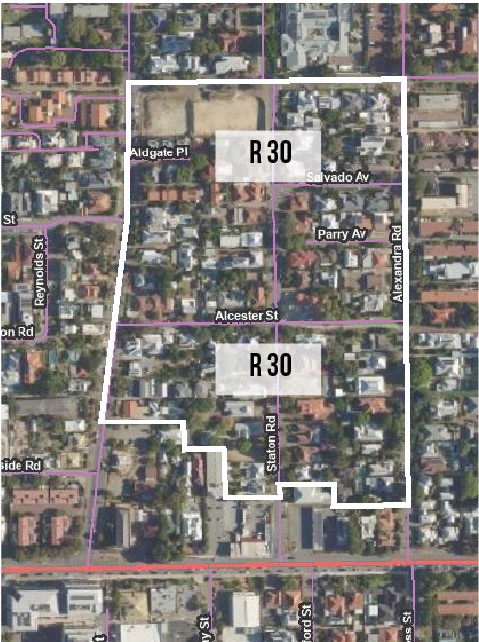
Alexandra, Wolsely and Osborne Road Streetblock
Local Planning Strategy Action - Urban Corridor
Investigate the potential to continue with the higher density pattern of housing development that already exists, or potentially increase this dwelling density (R-Code), for some properties in this Planning Area.
Planning Area H - existing R-Code
Planning Area H - proposed R-Code
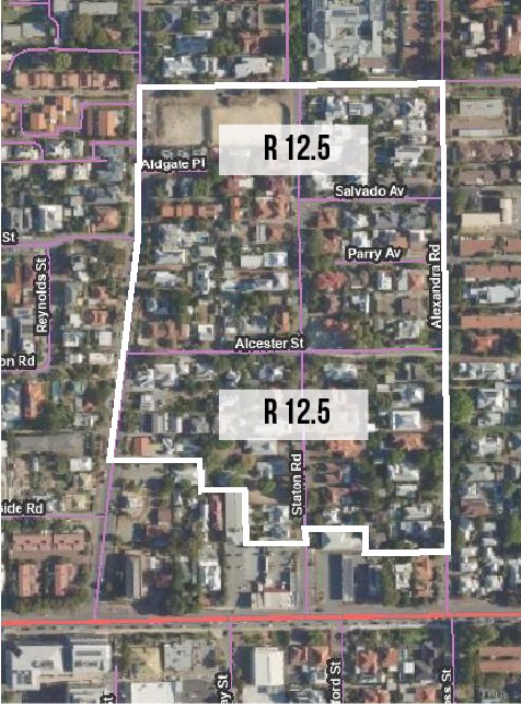
Planning Area I
Preston Point, Wolsely and Alexandra Road Streetblock
Local Planning Strategy Action - Urban Corridor
Investigate the potential to continue with the higher density pattern of housing development that already exists, or potentially increase this dwelling density (R-Code), for some properties in this Planning Area.
Planning Area I - existing R-Code
Planning Area I - proposed R-Code
Infill Development
Infill is the development of existing urban areas at a higher density than currently exists.
The Town is exploring the potential for infill development in the four Planning Areas F, G, H and I, as identified in the Local Planning Strategy.
The Strategy outlines reasons for considering a higher R-Code to permit infill development, these include:
- Town’s Housing Capacity Study (2018) identified potential for more housing.
- ~400m walkable catchment from the Town Centre, Petra St District Centre and Canning Hwy and Marmion St high frequency public transport for all Planning Areas.
- Some properties already subdivided and a similar development pattern may have potential to continue.
- Two to three storey townhouse, villa and grouped and multiple dwelling style housing potential which can incorporate heritage listed housing in all Planning Areas.
- Many existing non-conforming higher density developments and a variety of housing types (apartments, town houses, grouped and multiple dwellings) in Planning Areas H and I.
- Can incorporate heritage protected properties.
Based on the Perth and Peel @ 3.5 million objectives for urban corridors, a R30 density may be considered that is low rise development in Planning Areas F and G and a R30-40 density may be considered that is medium rise development for Planning Areas H and I.
What do the proposed dwelling densities look like?
The four Planning Areas have a strong local character, largely derived from many period homes that are heritage listed, generous landscaping and newer development that is sensitive to its surroundings.
It is important that new development continues to be of a form and scale that complements the existing housing stock and sense of place. There are many good examples of well-designed low and medium density housing.
The images on other panels illustrate how new development to a maximum density of R30 can be accommodated on lots of typical sizes. The various development scenarios demonstrate how additional housing, of varying types, can be accommodated behind an existing dwelling, (under the R-Code proposed for each Planning Area). The scenario of a vacant lot has also been applied as an example of what development might look like at the proposed R-Code.
Planning Areas F and G, H and I
Planning Areas F and G at proposed R30
Scenario 1: One additional house on a typical size lot (~980m² to 1,014m²) with an existing house.
This scenario is the easiest to achieve under a R30 coding for a typical lot with an existing house in the residential Planning Areas, even though it doesn’t fully utilise the potential of the R30 coding.
- One additional house on a battle-axe lot behind the retained house.
- Existing garage demolished to enable access to the rear house.
- New garage constructed for the front dwelling along with the new second house to the rear, both of which are accessed from a shared driveway.
What’s important
1. Retention of heritage or character houses.
2. Retain trees where possible.
3. Not all trees may be able to be retained.
4. One crossover only.
5. Single-width driveway to minimise crossover width.
6. Additions to the existing dwelling at rear to minimise change to streetscape.
7. New building to be consistent with the R-Code provisions wherever possible.
8. Similar roof forms to the existing dwelling.
9. Entrance to the new house to be visible from the street.
10. Architectural feature to terminate the vista down the driveway.
11. Private courtyards located behind the existing dwelling to enable privacy from the street.
Planning Areas F and G at proposed R30
Scenario 2: Rear yard of an existing dwelling on a typical lot subdivided for two grouped dwellings.
For a typical lot size (~980m² to 1,014m²), developing two grouped dwellings behind an existing house is unlikely to be achievable at a R30 coding given the space occupied by the existing dwelling.
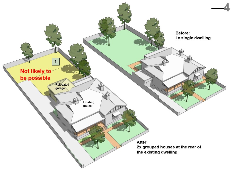
What's important
1. Consistency with the R-Code, which for R30 requires a minimum area of 260m² for the exclusive use of each new dwelling, requiring a minimum land area of 520m² at the rear.
2. The remaining available land area is likely to be less than 500m², so only one additional dwelling can be accommodated under the R-Codes.
Planning Areas F and G at proposed R30
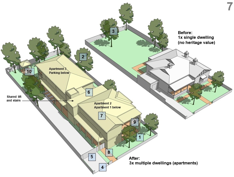
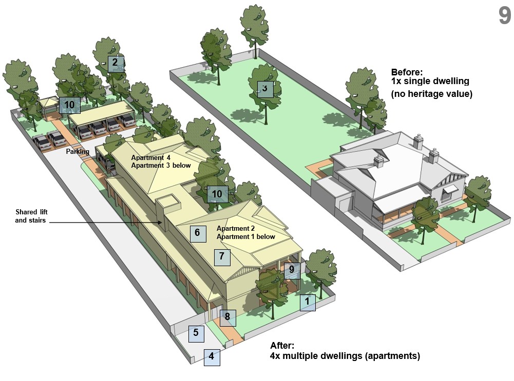
Scenario 3: Two additional multiple dwellings (apartments) on a typical sized lot (~980m² to 1,014m²) with an existing house.
Grouped dwellings may not be achievable behind an existing house on a typical lot, a small apartment building (two apartments) may be permissible subject to compliance with R- Codes and Council policy to ensure it ‘fits in’ with the local character.
Note: the built form is not unlike the single house in Scenario 1.
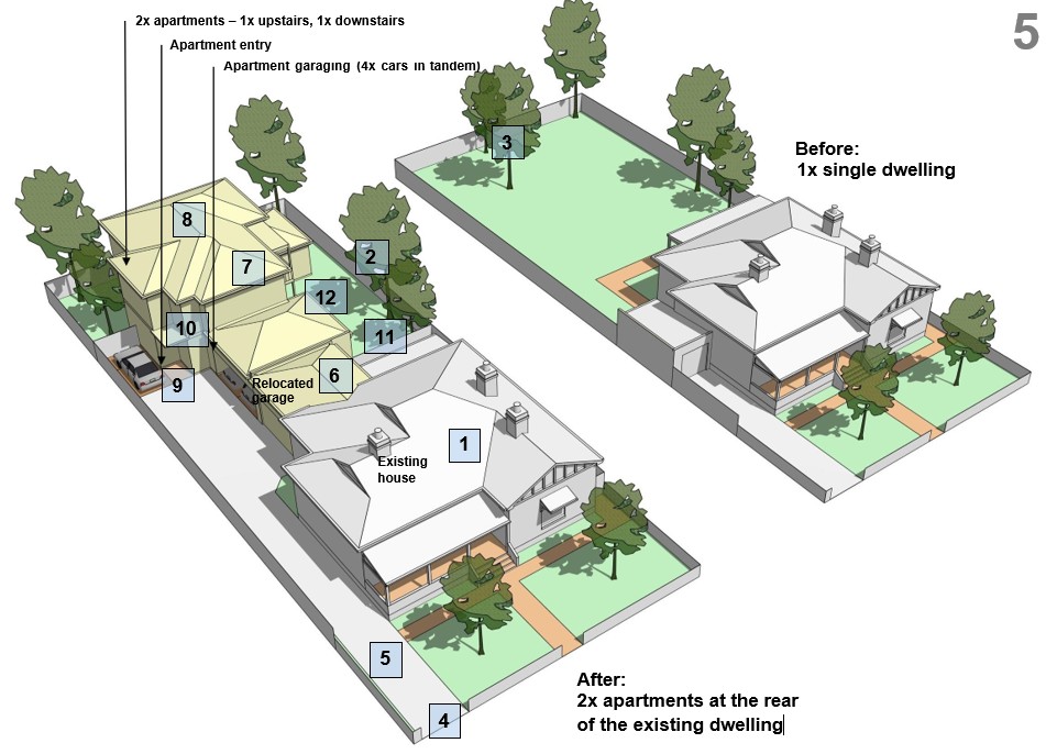
- Two additional apartments in a building behind the retained house.
- Existing garage demolished to enable access to the rear house.
- New garage constructed for the front dwelling along with the apartments to the rear, both of which are accessed from a shared driveway.
What's important
1. Retention of heritage or character houses.
2. Retain trees where possible.
3. Not all trees may be able to be retained.
4. One crossover only.
5. Single-width driveway to minimise crossover width.
6. Additions to the existing dwelling at rear to minimise change to streetscape.
7. New building to be consistent with the R-Code provisions wherever possible.
8. Similar roof forms to the existing dwelling.
9. Entrance to the new house to be visible from the street.
10. Architectural feature to terminate the vista down the driveway.
11. Private courtyards located behind the existing dwelling to enable privacy from the street.
12. Generous private and communal open space to provide amenity for residents.
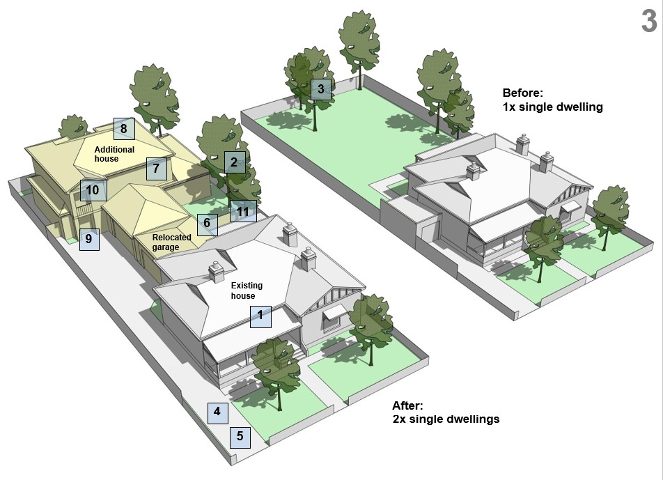
Planning Areas F and G at proposed R30
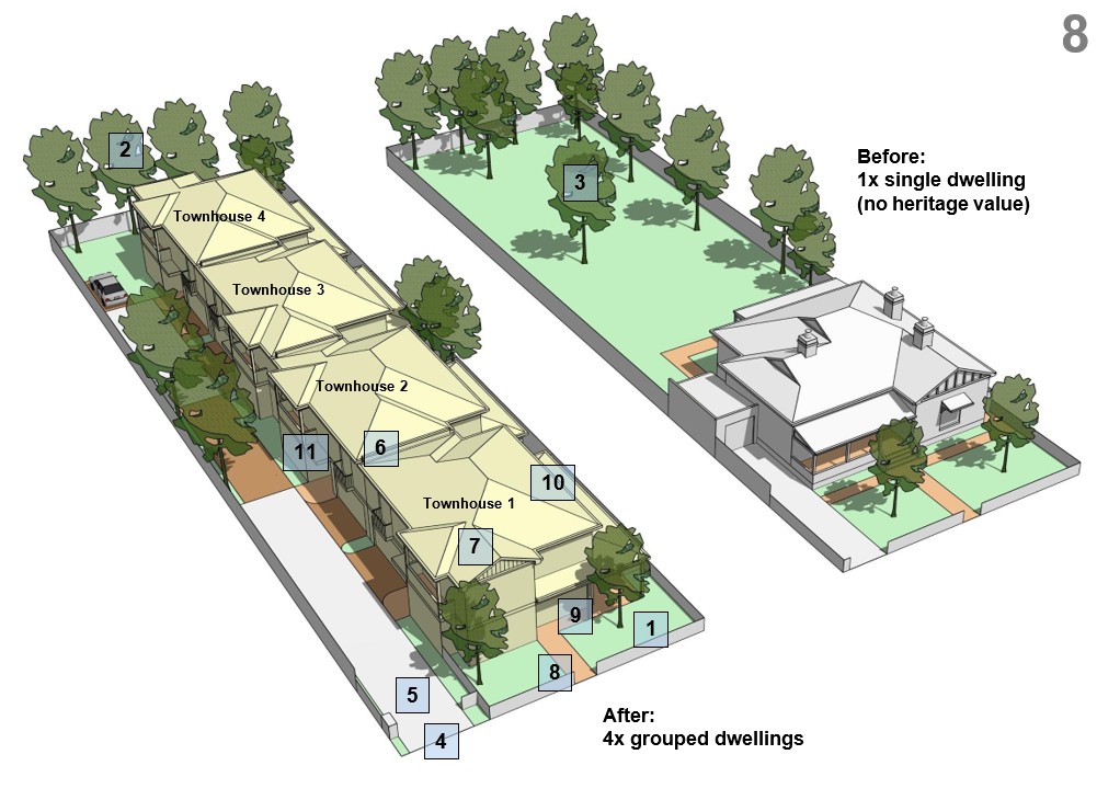
Scenario 4: Three grouped dwellings (townhouses) on a typical sized lot.
Where a typical lot (~980m² to 1,014m²) is vacant or unconstrained by heritage, it could be redeveloped as three grouped dwellings in a triplex style, subject to compliance with R-Codes and Council Policy to ensure it ‘fits in’ with the local character.

- Existing house (not heritage listed) demolished and replaced with 3 x 2 storey grouped dwellings (townhouses).
- All parking accessed via a shared driveway as per typical triplex development.
- More building bulk and less landscaping than the previous scenarios.
What's important
1. Optimise the extent of landscaping in the front setback.
2. Retain trees where possible.
3. Not all trees may be able to be retained.
4. One crossover only.
5. Single-width driveway to minimise the width of crossovers.
6. New buildings to be consistent with the relevant R-Code provisions wherever possible.
7. Pitched roofs and gables that reflect the prevailing architectural character.
8. Front dwelling to have an entrance directly from the street.
9. Front dwelling to include a verandah as part of the front elevation.
10. Private courtyards located behind the front setback to enable privacy from the street.
11. Use of balconies, gables and other architectural features to improve the presentation of the dwellings to the shared driveway.
Planning Areas F and G at proposed R30
Scenario 5: Three multiple dwellings (apartments) on a typical sized lot.
Where a typical lot (~980m² to 1,014m²) is vacant or unconstrained by heritage, it could also be redeveloped as three apartments subject to compliance with R-Codes and Council policy to ensure it ‘fits in’ with the local character.
- Existing house (not heritage listed) demolished and replaced with a two storey apartment building.
- Parking in an undercroft accessed via the driveway.
- Less building bulk than scenario 4 (three grouped dwellings) because the amount of floor space for multiple dwellings is controlled under the R-Codes. This will result in more room for landscaping.
What's important
1. Optimise the extent of landscaping in the front setback.
2. Retain trees where possible.
3. Not all trees may be able to be retained.
4. One crossover only.
5. Single-width driveway to minimise the width of crossovers.
6. New buildings to be consistent with the relevant R-Code provisions wherever possible.
7. Pitched roofs and gables that reflect the prevailing architectural character.
8. Building to have an entrance directly from the street.
9. Building to include a verandah and balcony as part of the front elevation.
10. Private courtyards and communal open space located behind the front setback to enable privacy from the street.
Planning Areas H and I at proposed R30
Note: Scenarios 1 to 5 are also applicable in Planning Areas H and I.
Scenario 6: Four grouped dwellings (townhouses).
In Planning Area I, there are some lots with areas of ~1,200m² to 1,518m². Where vacant or unconstrained by heritage, they could be redeveloped as four grouped dwellings in a quadruplex style, subject to compliance with R-Codes and Council policy to ensure the development ‘fits in’ with the local character.
- Existing house (not heritage listed) demolished and replaced with 4 x 2 storey grouped dwellings (townhouses).
- All parking accessed via a shared driveway as per typical townhouse development.
- Relatively large amount of building bulk and less landscaping.
What's important
1. Optimise the extent of landscaping in the front setback.
2. Retain trees where possible.
3. Not all trees may be able to be retained.
4. One crossover only.
5. Single-width driveway to minimise the width of crossovers.
6. New buildings to be consistent with the relevant R-Code provisions wherever possible.
7. Pitched roofs and gables that reflect the prevailing architectural character.
8. Front dwelling to have an entrance directly from the street.
9. Front dwelling to include a verandah as part of the front elevation.
10. Private courtyards located behind the front setback to enable privacy from the street.
11. Use of balconies, gables and other architectural features to improve the presentation of the dwellings to the shared driveway.
Planning Areas H and I at proposed R30
Scenario 7: Four multiple dwellings (apartments).
In Planning Area I, there are some lots with areas of ~1,200m² to 1,518m². Where vacant or unconstrained by heritage, they could be redeveloped as four multiple dwellings in a small apartment building subject to compliance with R-Codes and Council policy to ensure the development ‘fits in’ with the local character.
- Existing house (not heritage listed) demolished and replaced with a two storey apartment building.
- Parking in an undercroft accessed via the driveway.
- Less building bulk than scenario 6 (4 x grouped dwellings) because floor space for multiple dwellings is constrained under the R-Codes. The result of this is that there will be more room for landscaping.
What's important
1. Optimise the extent of landscaping in the front setback.
2. Retain trees where possible.
3. Not all trees may be able to be retained.
4. One crossover only.
5. Single-width driveway to minimise the width of crossovers.
6. New buildings to be consistent with the relevant R-Code provisions wherever possible.
7. Pitched roofs and gables that reflect the prevailing architectural character.
8. Building to have an entrance directly from the street.
9. Building to include a verandah and balcony as part of the front elevation.
10. Private courtyards and communal open space located behind the front setback to enable privacy from the street.
Planning Areas H and I at proposed R30
Scenario 8: Six grouped dwellings (townhouses)
In Planning Area H, there are some lots with areas of approximately 2,031m² to 2,049m². Where vacant or unconstrained by heritage, they could be redeveloped as six grouped dwellings subject to compliance with R-Codes and Council policy to ensure the development ‘fits in’ with the local character.
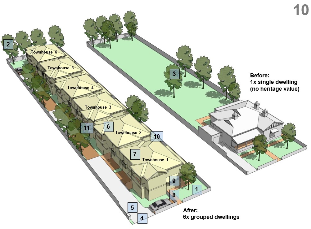
- Existing house (not heritage listed) demolished and replaced with 6 x 2 storey grouped dwellings (townhouses).
- All parking accessed via a shared driveway as per typical townhouse development.
- Relatively large amount of building bulk and less landscaping.
What’s important
1. Optimise the extent of landscaping in the front setback.
2. Retain trees where possible.
3. Not all trees may be able to be retained.
4. One crossover only.
5. Single-width driveway to minimise the width of crossovers.
6. New buildings to be consistent with the relevant R-Code provisions wherever possible.
7. Pitched roofs and gables that reflect the prevailing architectural character.
8. Front dwelling to have an entrance directly from the street.
9. Front dwelling to include a verandah as part of the front elevation.
10. Private courtyards located behind the front setback to enable privacy from the street.
11. Use of balconies, gables and other architectural features to improve the presentation of the dwellings to the shared driveway.
Planning Areas H and I at proposed R30
Scenario 9: Six multiple dwellings (apartments).
In Planning Area H, there are some lots with areas of approximately 2,031m² to 2,049m². Where vacant or unconstrained by heritage, they could be redeveloped as six grouped dwellings subject to compliance with R-Codes and Council policy to ensure the development ‘fits in’ with the local character.

- Existing house (not heritage listed) demolished and replaced with a two storey apartment building.
- Parking in an undercroft accessed via the driveway.
- Less building bulk than scenario 6 (4 x grouped dwellings) because floor space for multiple dwellings is controlled under the R-Codes. The result of this is that there will be more room for landscaping.
What’s important
1. Optimise the extent of landscaping in the front setback.
2. Retain trees where possible.
3. Not all trees may be able to be retained.
4. One crossover only.
5. Single-width driveway to minimise the width of crossovers.
6. New buildings to be consistent with the relevant R-Code provisions wherever possible.
7. Pitched roofs and gables that reflect the prevailing architectural character.
8. Building to have an entrance directly from the street.
9. Building to include a verandah and balcony as part of the front elevation.
10. Private courtyards and communal open space located behind the front setback to enable privacy from the street.
Have your say
Community feedback
The process of drafting and seeking approval for LPS 4 is heavily regulated and includes a formal community consultation process once a draft of LPS 4 has been written.
The Town is hoping to reduce the time taken to complete the Scheme by engaging with the community at an earlier point in the process where feedback and ideas can be properly considered, and where appropriate, incorporated.
The Town is seeking the community’s feedback on the initial dwelling density proposals for the Planning Areas F, G, H and I which may be included in LPS 4 subject to Council endorsement.
The feedback received from this drop-in session will be collated and presented to Council for its consideration at the earliest opportunity.
Feedback forms are available to complete via the Town’s website or scan the QR code.
To assist with feedback, it is requested you complete the online feedback form. This allows for targeted feedback about specific aspects of the proposals for the Planning Areas.
If completion of an online form is not possible, the feedback form will be made available at the Town Hall and can be submitted by email at admin@eastfremantle.wa.gov.au.
What's next for community input into LPS 4?
In 2026 the community will be invited to consider the proposed zoning, land use, dwelling density, development controls, and traffic impacts for the Town Centre, through a series of workshops and open day(s). These events are scheduled to occur in the first half of 2026. A further opportunity to provide feedback will be available at that time.
The community’s input will then be used to inform the preparation and final draft of LPS 4 (Scheme Text and Map). The Council and the WAPC will then consider whether the Scheme is suitable for formal advertising. An advertising and submission process will then take place on the final draft. The community will be invited to make submissions during the official 90 day advertising period.